Another great video by C0nc0rdance showing the importance of vaccination. I have covered this before, for some reason my prior post has been getting tons of hits recently, and just in the last few days a new report was released which showed, shockingly, that vaccines do not cause Autism (NPR article on the report). The report did show that vaccines have side effects, this is not surprising as almost all medicines do, but that the side effects were typically minor especially when compared to the harm the actual disease would have done.
Friday, August 26, 2011
Population
So this is something that you hear a lot coming from creationists, mostly because they are just regurgitating Kent Hovind, that the population now can only have been reached with an initial population of 2. This new video by shanedk should at least partially answer that question.
Wednesday, August 24, 2011
Big Bend National Park
Location: Western Texas in Southernmost Brewster County along the border with Mexico.
Introduction:
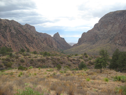
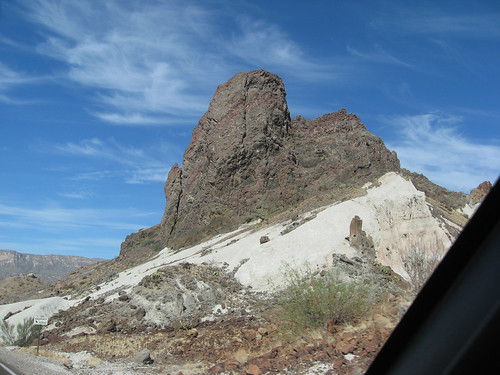
I have been wanting to do a post on Big Bend for a long time, mainly because most of my fellow paleontology graduate students were doing work on material from here, but I couldn't put a post together till I had been there [Image at top looking out the Window in the Chisos by author]. Finally as I was getting ready to leave Lubbock I convinced one of the other students to drive out there with me for a couple of days so I can now say I have been even if we played tourist at the end of July and were trying not to melt the whole time we were there (note: it is hot in the desert in July).
Big Bend National Park (Wikipedia page) is not a national park that you just happen upon you have to make the conscious effort to get there. The fact is even the county it is in is off most peoples beaten path, there are no interstates that go through the county, and with a population of ~10,000 people very few people will ever visit the area. Big Bend is also in the middle of a desert which most people tend to avoid, especially during the hot summers which also happen to be when most tourists visit the other national parks. All of these reasons make Big Bend one of the least visited of the parks in the NPS system.
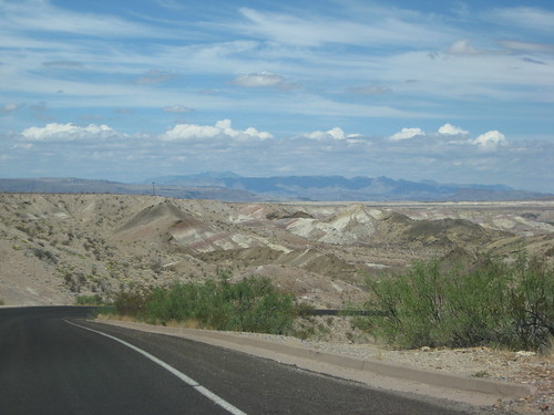
I mentioned that Big Bend is in the desert and it is part of the Chihuahuan Desert this desert extends up into New Mexico in fact 2 previous national park series posts, Guadalupe Mountains and Carlsbad, have talked about parks in this desert. Now this is not the desert that most people picture when they think desert, there are no big cacti and tons of sand. What there is instead is a very dry environment with for the most part low growing plants that have adapted to be able to live with little to no water for extended periods of time and when they do get water they make the most of it. There is plenty of mesquite as well with its long roots that reach deep for water and can find water in even the driest of environments. But there is more than just desert as the park varies from 1800 feet up to over 7000 feet there is a wide range of climatic differences. The Rio Grande and its flood plain make of a rich fertile wet soil that keeps plants growing almost year round and in the valley actually makes it quite humid. The desert has two ranges one the high desert and the other the low desert both have unique and varying vegetation types. And finally the Chisos Mountains that extend from the desert floor reaching up to the sky, the basin in them where the campsites are is over a mile high, the micro-climate here is cooler, I woke up in the morning actually cold and wanted to put on a long sleeve shirt, and more wet than the surrounding area and is the only place in the park where true trees can and do grow, also home to bears and mountain lions.
Ok I have rambled on long enough with the intro but lets just say if you happen to be nearby for whatever reason go visit Big Bend it is worth your time.
Geology:
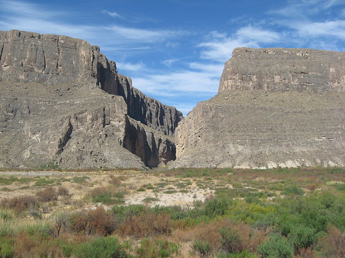 This park is so large (~800,000 acres) and has such a vast diverse geologic history that this is really only going to be an extremely brief summary of the geology of the park because I could ramble on for a long time about it [Image at left of Santa Elena Canyon by author].
In the Triassic while Pangaea was still around this area of the country was exposed to the surface so unlike good chunks of the rest of the state there are no Triassic rocks in Big Bend. During the Triassic and Jurassic, however, Pangaea began to break apart this caused many of the rift valleys on the east coast of the United States and slowly started to allow for subsidence of the middle portion of the country. By the Cretaceous a large body of salt water that connected the still forming Gulf of Mexico to the Arctic Ocean, this was known as the Western Interior Seaway. This seaway was shallow and warm which is the perfect conditions for calcium carbonate secreting organisms to live in and these organisms form limestone deposits, see Guads, Carlsbad, and Mammoth Cave posts. These limestone deposits form the famous Glen Rose Formation in most of Texas along with most of the other limestone formations in the center of the state, they also form the limestone and chalk formations up into Kansas where the less famous, but equally important, Niobrara Chalk is. In the park there are thin bands of the Glen Rose but the most obvious example of this limestone is the massive limestone cut by the Rio Grande to form Santa Elena Canyon.
Late in the Cretaceous the sea level fell and the Western Interior Seaway began to recede toward the Gulf of Mexico, in the U.S. at least. As the sea level dropped river systems began to flow through the region and toward the very end of the Cretaceous portions of the park where underwater and portions where on land. During this time many dinosaurs lived in the area and in the formations that represent this time we find their fossils. The dinosaurs weren't alone during this time as the pterosaurs had grown to their largest size yet and Big Bend represents the type location of one of the largest the ~10 meter wing spanned Quetzalcoatlus northropi (Wikipedia page). The actual contact that represents the end of the dinosaurs, that famous iridium layer, is not found in the park although it should be no one has found the contact yet, although we are still looking.
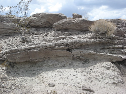 Whatever happened to the contact the area continued on being a warm wet swampy habitat through a good portion of the Eocene, fossils from the mammals that lived at this time can be seen at a roadside stop known as the Fossil Bone Exhibit in the park [photo at right of the Eocene sedimentary rocks near the fossil bone exhibit by author]. These animals were sitting on a ticking time bomb, however, because while they were living here under their feet were building up massive igneous intrusions.
These igneous rocks would eventually burst through eventually and would form the Chisos Mountains. There were likely at least 3 major events of eruption and evidence throughout the park is obvious. In an area known as Tuff Canyon, tuff is a type of volcanic ash, there are ash rocks that have been heavily cut by water but in the ash layers there are evidence of lahars and lava bombs. Eventually the composition of the magma changed and it came out more runny this formed areas where you have lava being deposited on top of ash and they are exposed for many meters in elevation. The igneous rocks shaped the park and through the area there is evidence of volcanics but also plenty of evidence of intrusives as igneous dikes cross roads in several places.
Volcanism eventually stopped and the area settled tectonically but it wasn't quite done yet. As with the Guads there was at least one period of uplift formed as the western edge of the Basin and Range that uplifted many of the rocks and with the help of erosion giving us the geography we have now. The park has obviously also become a desert and this likely occurred closer to the end of the last ice age as climates every fluxed due to the change in flow patterns caused by the loss of the glaciers.
More Pictures: I have even more pictures in the Big Bend portion of my Flickr page, all photos by author.
More "runny" volcanic rocks on top of an ash layer.
Cretaceous aged sedimentary rocks
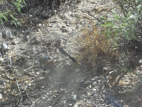
Roadrunner
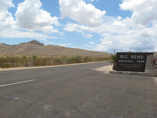
Welcome to Big Bend National Park
Further Reading:
The NPS pages on the Geology of Big Bend and the Fossils of Big Bend, as well as all the links included in the fossil page.
Long and very technical USGS Circular 1327: Geological, Geochemical, and Geophysical Studies by the U.S. Geological Survey in Big Bend National Park, Texas from 2008, from that link you can download the whole thing.
See many of the papers by Dr. Tom Lehman at Texas Tech University, and if you walk through the second floor of the building near his office you will see other posters and papers of his and his students research.
National Park Service Series homepage
Wednesday, August 10, 2011
It has been a hot one
This summer for much of the United States has been record breakingly hot. Greenman3610 goes to show how this fits in with what we know about climate change in his newest video. Now I should point out, as I have in the past, that one single hot event does not signal Global Warming/Climate Change, but it is when we continual set or get close to setting records year after year. The way this year is going it looks like yet another summer in that will be in the top 10 for temperatures.
Colbert on Global Warming
Stephen Colbert does it again not only does he not believe in climate change but he no longer believes in warming! This is why I watch the Colbert Report every night.
Argh/Fail!!!
So apparently my previous post got cut off at the bottom, due to an error in my coding, that will teach me to do my own HTML. Here is the rest of the post that got cut off, it isn't very much.
[...]While we were down there the group Yaguará was selling T-shirts whose proceeds went to them so they could purchase more equipment.I fixed the problem on the previous post if you want to see it in context, hopefully I can avoid doing this again.
As I mentioned earlier this is the last post in this series so I hope that you enjoyed it. If you didn't I'm sorry, I guess, but we will get back to normal posts, YouTube science videos and random comics with some actual though involving posts thrown in randomly, here shortly. As always feel free to leave comments in the comments below or send me a message!
Monday, August 8, 2011
Costa Rican Big Cats
So this will be the last post in this series but it is also the one I was looking forward to the most, but before I get into the meat of the post I want to add something to primarily the previous post in this series but it could also be added to the one before that.
How do I forget about fossils?
Well to put it simply it is because there aren't any. As I discussed in the previous post there is very little soil and if it isn't secured by roots it washes away quickly but I also mentioned that anything that dies in forest gets reused very quickly. For these reasons fossils are rare to nonexistent. You need to have sediment being laid down in order to preserve fossils and there are just too few areas in Costa Rica where this is occurring, although there are probably some I just don't know of any. This means that the fossil record for animals that lived and evolved in Costa Rica tends to be pretty sparse. That is not to say there isn't the potential for fossils to be found, after all the crew at the University of Florida have several sites in neighboring Panama where work is being done to widen the canal so who knows what the future holds.
Back on topic!
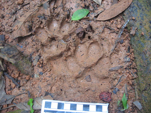 The presence of big cats in Costa Rica should come as no surprise after all the Jaguar ranges from Mexico, rarely the U.S. Southwest, through most of South America. What actually surprised me was the presence of Pumas, or Mountain Lions/Cougars/etc, in Costa Rica because when I think of them I think of the Western U.S. My surprise aside, I was sad to hear that our second night there there was going to be a talk at the hotel about the big cats [photo at left of most likely Ocelot footprints, by author] in the region but we were already scheduled for another tour. After confirming that the people giving the talk would be back later we were relieved and so a few nights later my wife and I sat down for what would be a very interesting talk.
The talk was given by Aida Bustamante from the conservation group Yaguará. The group is trying to make sure that the big cats in Costa Rica continue to be protected and can flourish. The research that the group has done is impressive and Aida gave an interesting talk, my wife and I were glad to have gone and told her so afterward.
The group has been working to try to change people's minds about the big cats. They have approached this in a couple of ways. The first way is by putting out camera traps around the national park as well as at many of the ecolodges. The ecolodges protect their forests because they know that is what brings tourists to them when a big group of these are located near each other, like on the Osa Peninsula they allow for animals to cross vast expanses of land like they would have before humans started cutting down the forests. The Osa Peninsula has plentiful forests and the big cats love it this allows for the presence of ocelots and pumas as well as other large cats and hopefully the jaguars. Giving talks like the one I attended is a way to reach these tourists to help protect these areas.
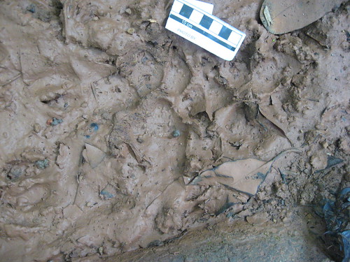 Another way they are trying to protect the cat is through community outreach. This is done in two main ways the first is giving talks, like the one I saw, to the community and let them know the cats are out there but they are not very likely to hurt people [Photo to right of footprints potentially of a Puma I am actually unsure but based on size and shape that is what my wife and I decided, by author]. This includes not just going to schools but going to people's homes an places of work to give the talks. The other way is by paying ranchers the cost of any livestock that is killed by the big cats. This prevents the ranchers from going out to kill the animal that killed their livestock in a hope to recoup some of the loss, something that ranchers even here in the U.S. do.
Evidence of big cats is everywhere on the Osa, as noted by the two photographs on this post, and the camera traps have captured evidence of all of the big cats including jaguars. The jaguars need vast expanses of territory to roam, however, so they cannot just be confined to the Osa. Evidence from camera traps suggest that they have traveled to another national park across the bay from where we were. This is a good sign but the possibility remains that they could eventually get cut off. Prior to the 2008 economic downturn there were plans in the work the keep the areas connected by forest and allow this forest to be part of a larger transnational forest that runs most of Central America down to South America. When everyone's economy crashed in 2008 this was put on hold. Now there is talk of the President of Costa Rica opening up forest land to mining and farming, this would obviously hurt the ranges of the big cats.
But there is hope! As I mentioned the big cats are traveling and this wasn't heard of until recently so this is good news. The number of cats seems to be increasing and their prey items so to also be seeing a rise which means there are likely to be more cats to prey on these animals.
I hope that by raising attention to this issue here someone outside will notice. I went to Costa Rica because of the rain forest. This area represents a wild that we don't get to see here in the U.S. or Europe and I would hate to see that changed. Dollars often speak louder than words and my dollars were spent on things that allowed me to see the wildlife while down there. Enough about me is there anything you can do to help? Well you can write the government down there and let them know if you have been, are going to, plan to, or just want to go to Costa Rica and let them know how you feel about this topic. You can also donate to Yaguará, also see here, or other organizations that are working on preserving the Costa Rican environments. While we were down there the group Yaguará was selling T-shirts whose proceeds went to them so they could purchase more equipment.
As I mentioned earlier this is the last post in this series so I hope that you enjoyed it. If you didn't I'm sorry, I guess, but we will get back to normal posts, YouTube science videos and random comics with some actual though involving posts thrown in randomly, here shortly. As always feel free to leave comments in the comments below or send me a message!
How do I forget about fossils?
Well to put it simply it is because there aren't any. As I discussed in the previous post there is very little soil and if it isn't secured by roots it washes away quickly but I also mentioned that anything that dies in forest gets reused very quickly. For these reasons fossils are rare to nonexistent. You need to have sediment being laid down in order to preserve fossils and there are just too few areas in Costa Rica where this is occurring, although there are probably some I just don't know of any. This means that the fossil record for animals that lived and evolved in Costa Rica tends to be pretty sparse. That is not to say there isn't the potential for fossils to be found, after all the crew at the University of Florida have several sites in neighboring Panama where work is being done to widen the canal so who knows what the future holds.
Back on topic!
The presence of big cats in Costa Rica should come as no surprise after all the Jaguar ranges from Mexico, rarely the U.S. Southwest, through most of South America. What actually surprised me was the presence of Pumas, or Mountain Lions/Cougars/etc, in Costa Rica because when I think of them I think of the Western U.S. My surprise aside, I was sad to hear that our second night there there was going to be a talk at the hotel about the big cats [photo at left of most likely Ocelot footprints, by author] in the region but we were already scheduled for another tour. After confirming that the people giving the talk would be back later we were relieved and so a few nights later my wife and I sat down for what would be a very interesting talk.
The talk was given by Aida Bustamante from the conservation group Yaguará. The group is trying to make sure that the big cats in Costa Rica continue to be protected and can flourish. The research that the group has done is impressive and Aida gave an interesting talk, my wife and I were glad to have gone and told her so afterward.
The group has been working to try to change people's minds about the big cats. They have approached this in a couple of ways. The first way is by putting out camera traps around the national park as well as at many of the ecolodges. The ecolodges protect their forests because they know that is what brings tourists to them when a big group of these are located near each other, like on the Osa Peninsula they allow for animals to cross vast expanses of land like they would have before humans started cutting down the forests. The Osa Peninsula has plentiful forests and the big cats love it this allows for the presence of ocelots and pumas as well as other large cats and hopefully the jaguars. Giving talks like the one I attended is a way to reach these tourists to help protect these areas.
Another way they are trying to protect the cat is through community outreach. This is done in two main ways the first is giving talks, like the one I saw, to the community and let them know the cats are out there but they are not very likely to hurt people [Photo to right of footprints potentially of a Puma I am actually unsure but based on size and shape that is what my wife and I decided, by author]. This includes not just going to schools but going to people's homes an places of work to give the talks. The other way is by paying ranchers the cost of any livestock that is killed by the big cats. This prevents the ranchers from going out to kill the animal that killed their livestock in a hope to recoup some of the loss, something that ranchers even here in the U.S. do.
Evidence of big cats is everywhere on the Osa, as noted by the two photographs on this post, and the camera traps have captured evidence of all of the big cats including jaguars. The jaguars need vast expanses of territory to roam, however, so they cannot just be confined to the Osa. Evidence from camera traps suggest that they have traveled to another national park across the bay from where we were. This is a good sign but the possibility remains that they could eventually get cut off. Prior to the 2008 economic downturn there were plans in the work the keep the areas connected by forest and allow this forest to be part of a larger transnational forest that runs most of Central America down to South America. When everyone's economy crashed in 2008 this was put on hold. Now there is talk of the President of Costa Rica opening up forest land to mining and farming, this would obviously hurt the ranges of the big cats.
But there is hope! As I mentioned the big cats are traveling and this wasn't heard of until recently so this is good news. The number of cats seems to be increasing and their prey items so to also be seeing a rise which means there are likely to be more cats to prey on these animals.
I hope that by raising attention to this issue here someone outside will notice. I went to Costa Rica because of the rain forest. This area represents a wild that we don't get to see here in the U.S. or Europe and I would hate to see that changed. Dollars often speak louder than words and my dollars were spent on things that allowed me to see the wildlife while down there. Enough about me is there anything you can do to help? Well you can write the government down there and let them know if you have been, are going to, plan to, or just want to go to Costa Rica and let them know how you feel about this topic. You can also donate to Yaguará, also see here, or other organizations that are working on preserving the Costa Rican environments. While we were down there the group Yaguará was selling T-shirts whose proceeds went to them so they could purchase more equipment.
As I mentioned earlier this is the last post in this series so I hope that you enjoyed it. If you didn't I'm sorry, I guess, but we will get back to normal posts, YouTube science videos and random comics with some actual though involving posts thrown in randomly, here shortly. As always feel free to leave comments in the comments below or send me a message!
Thursday, August 4, 2011
Conservation in Costa Rica
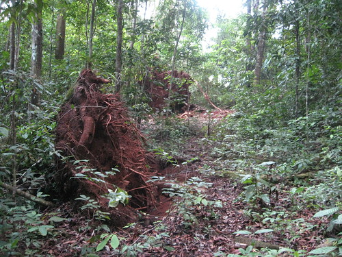 This post is going to pick up where the previous Costa Rica post left off because it is important to understand. When most people think of rain forests like the ones that exist in Costa Rica they think of plentiful large plant life and lots of exotic animals. This often leads to the association of plants in more temperate areas that have extensive amounts of soil under them. Well what you should notice based on the picture to the left [photo of a root ball on a tree in Costa Rica by author, I could not find a more temperate forest root ball to compare it to so if you know of one feel free to post the link below] is that this is not true. The actual soil in most rain forests is typically very thin but why is this and what does this have to do with conservation?
Well the reason for this is due directly to the large amount of plants and animals along with the large amount of rain that occur in rain forests. When a dead organisms falls to the ground in a more temperate forest decay begins immediately but is slowed by a lower amount of rain and as one goes further north colder winter temperatures. In the rain forest you have warm humid climatic conditions year round, these are ideal conditions for decomposers so decomposition takes place very quickly. This means in order for plants and animals to get nutrients from decomposing organisms they must be able to do so quickly so this leads to a huge competition for these nutrients and with so many organisms competing for these nutrients the soil very quickly depletes the soil.
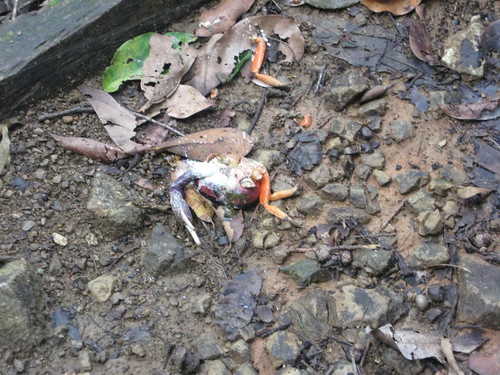 Rain also effects the soil in any given environment. If a farmer clears land then it proceeds to rain the rain will wash away some of the soil. The same thing occurs in nature in forests as well. In a temperate forest the rain may wash away some of the soil but typically plants grow up in the thicker soil before the rain has a chance to wash it away and the plants help lock down the soil. In rain forests we have a perfect storm we have already thin soil and we have plentiful pretty much daily rain so before plants have a chance to start growing a lot of the soil is lost [photo at right of a dead crab, you can ignore this for this post on very depleted soil by author]. This leads to areas where the soil remains exposed we end up with typically iron and felsic rich soils. These soils do not have the nutrients that are needed to support plant life and do to the large amount of rain it is hard to get plants to regrow in these areas. So what does this mean?
This basically means that if we cut and burn and start trying to farm is these types of environments we lose most of the soil very quickly so we need more land. The land that had been farm land does not grow any plants anymore and continues to become more and more enriched in iron etc and gets more and more depleted in nutrients. This land eventually becomes almost rock like and will not grow plants so the farmers need more land so they slash and burn more land in the forest to be able to grow more crops, this is a big problem in places like Brazil.
Humans need food, however, so we need to do something. Well there are a couple ways to address this the first is that these countries could import food from countries that do not have similar problems. This is expensive, however, and leaves that country open to manipulation by foreign countries in exchange for food and as such is not preferable. The other main option is a crop rotation pattern. You could allow native plants to grow for a little while develop a more native soil pattern then cut it back and farm it for a couple of years then allow the forest to come back. This idea in and of itself isn't perfect and in the long run could prevent a country from growing enough food to support itself.
So which is best? I can't say and in fact their could be other options that I did not list here, feel free to put some in the comments section. It is important to note that in many parts of Costa Rica the locals have, however, taken advantage of the more natural way of growing food in many areas and if you stay try to stay at a ecolodge. These ecolodges typically produce their power and get food from sustainable sources which is good for Costa Rica and the world in general. The next post will also partially deal with conservation but in a slightly different way, as always I more than welcome your questions or comments below.
Wednesday, August 3, 2011
Fire Breathing Dinosaurs?
In Potholer54's continuing nominations for this year's Golden Crocoduck award he nominates the man who first popularized the idea about dinosaurs having too small nostrils...well just watch the video.
Artifical Sweeteners
I have been moving across the country so I have obviously failed at finishing my Costa Rica series and I have yet another National Park series post to write, but while I finish unpacking enjoy yet another great video by C0nc0rdance this time discussing the actual science behind artificial sweeteners and do they really give you cancer, as a diabetic I found this a helpful video (note: this video is 24 minutes long).
Subscribe to:
Posts (Atom)