
This article is a continuation of the series that I started a few days ago discussion several select topics in relation to my recent honeymoon to Costa Rica more specifically the Osa Peninsula. Now I am going to lead this article off by admitting that for the most part this topic seems to be under researched overall. There are a lot more personal observations in here than there are sources to peer reviewed published citations, which I am pretty upset about personally, so I do recommend you do your own research to find out more. I should point out that there are 3 sources (here, here, and here) that if I would have had access to them may have added some to the discussion here, so if you have read them feel free to post anything you know in the comments.
Overall Costa Rican Geology
The map at the top of the article was first published by the USGS in 1987. It has since been updated and digitized in 1996 by Paul G. Schruben, see larger version of the map here. So why am I using a map from 1987, the map is only a year younger than I am that should say something? Well the reason is that this is the only geologic map of the country that I could find so I am sure that it is slightly out of date. On another note here is the website for the Costa Rican Geological Survey.
Two things I notice right away just by looking at the map is that there is a lot of igneous rocks in the country and that there are not rocks visible on the surface that are older than the Jurassic. Both of these things exist for the same reason. When the continents first started rifting apart from the super continent of Pangaea North and South America were not connected, at least not in the same way they are today. This rifting because in the late Triassic/early Jurassic and the rates and directions of spreading varied in different parts of the Atlantic. This is why the oldest rocks are Jurassic in age. For millions of years the two Americas remained separated but eventually the Pacific Plate began to subduct under the North American Plate and the Caribbean Plate. This subduction caused more and more of Central America to be pushed up so for a bunch of volcanic islands to what we have in Costa Rica and Panama now, this initiated what is known as the Great American Interchange. According to discussions that I had while in country the Pacific Plate underwent a very shallow subduction this is what caused many of the volcanoes in the center of the country become dormant or extinct. These seems plausible but I don't know enough about the study in the area to be able to say for sure, I am going to admit here that Igneous and Metamorphic rocks were never my strong suit so I welcome anyone else to say if they know better.
Geology of the Osa Peninsula
 The Osa Peninsula and the Gulfo Dulce represent a very unique geologic set up compared to the rest of the country. A lot of travel brochures refer to Gulfo Dulce as a "tropical fjord" due to the great depth of the gulf and the steep drop-off to that depth as well as the surrounding land being mountainous. Fjord by definition cannot form in tropical environments because they need to be formed by glaciers, which this gulf was not, and they need to have more of a u-shape as well as having the mountain slopes forming right up to the edge of the water. But what explains the great depth?
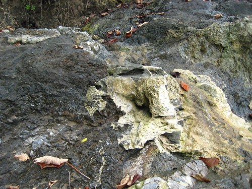
This is actually a pretty simple answer the Osa Peninsula is composed primarily of basalt. Basalt is a rock that is typically associated with ocean floor rocks and differs from continental igneous rocks which tent to have more silica in them and as such are actually less dense than basaltic rocks. So the depth of the Gulfo Dulce is due to the fact that as the Pacific plate subducted under the Caribbean Plate the Osa Peninsula was pushed up on the Pacific plate side. So the gulf actually represents the spot where the Pacific plate is subducting and is just a continuation of the trench that runs along the Pacific coast of most of South and Central America. But why did the Osa Peninsula not subduct with the rest of the Pacific Plate?
A completely honest answer is that we (or maybe just I) don't know. This is one of the great things about science is that we can admit that but I can put through a couple of hypotheses that can eventually be tested. The first one is that the Osa Peninsula represents a spot where the Pacific plate has bent to such a high degree that it caused the Peninsula to be pushed up above water and eventually it will be subducted eventually. Now by itself I don't think this explains the Peninsula or we would expect to see a great many more islands like this following the boundary of the Pacific Plate. Another possibility is that for some reason the basalt that forms the rocks on the Osa Peninsula is less dense than the normal basalt. As I explained above silica rich rocks tend to be less dense than the basaltic rocks and running through the basalts visible on the beach were many many quartz seams. Quartz is made up of Silica and Oxygen and is a typical constituent of continental rocks, it is also the main constituent of most beach sands. This would have made the rocks less dense and more likely to but uplifted and less likely to be subducted which would cause the Osa Peninsula to stick up and eventually be accreted to the mainland of Central America. Now I will admit I like this last one better but it is honestly just a very basic hypothesis.
One more thing I hadn't noticed that there are supposed to be a lot of sedimentary rocks on the Osa Peninsula. Now while these break down before they can be seen on the surface and are likely just covering the basaltic rocks they aren't talked about much. Something you may notice in the picture that I posted at the start of this section is that yellow staining on the basaltic rocks, this picture was taken by the author and shows some of the rock visible on the Pacific side of the Osa Peninsula. Soil is thin in the area and most of these smaller streams don't carry much in the way of physical sediments what this yellow staining looked a lot like to me is travertine. This could be resulting from the few limestone rocks on the peninsula dissolving and the calcite reprecipitating on the rocks at the beach, if you want to know more about travertine look at my two posts on two of the caves in the National Park system, here and here. This post went far longer than I would have liked and there is another aspect I would like to cover that I can tie into another post so that is what I will try to do, also I should point out that I only just barely touched on some complicated topics so if you have any questions about any of that let me know. If you want to read a little bit more about this area geologically read this article from 2009 in Earth Magazine.

Hi thankś for uploading rock pictures of this area ,not many people do so
ReplyDeletewhat was the thickness of this strucure ?
also wondering if this ophiolitic structure was all quarziferous or if there was softer talkum / waxlike
black material ( periodite crust )as can be seen here :
http://geology.about.com/od/more_igrocks/ig/peridotite/peridcrust.htm
eventually also present in or at the border of the contact ?
Sorry it took me so long to get back to you about this. To be honest I cannot completely answer either of your questions. We were in a hurry due to the quickly rising tide so we didn't spend much time examining the rocks down there. The thickness could be anywhere from around 3 meters to I would guess ~100 meters but as the forest very quickly overgrows the exposed rocks it is hard to say. As for the comment about the periodite crust I can't answer that one way or another, again we were in a hurry, but I can give you the information for the resort we stayed at and they may be able to have someone look more thoroughly, although being located in a rainforest they do not have a geologist on staff just a biologist so I am not sure how much they would be able to help in that regard.
Delete